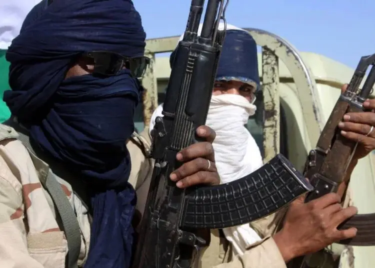


Since January 3, Boko Haram militants have attacked almost on a daily basis the area surrounding Baga, a fishing settlement on the shores of Lake Chad in Nigeria’s northeast Borno State.
The exact death toll in Baga and 16 surrounding villages is unknown, with estimates ranging from “dozens” to 2000 or more. “No one stayed back to count bodies,” one local resident told Human Rights Watch. “We were all running to get out of town ahead of Boko Haram fighters who have since taken over the area.”
Satellite imagery acquired by Human Rights Watch reveals evidence of large-scale destruction, particularly in the town of Doro Gowon, the site of the Multinational Joint Task Force (MNJTF) base, a few kilometers from Baga. Nigeria, Chad, and Niger established the MNJTF in 1998, initially to check criminal activities in the border areas between the three countries. The MNJTF expanded in 2012 to include Cameroon and Benin and cover counterterrorism operations against Boko Haram in the region.
The satellite images, taken in the days following the attacks, provide direct evidence of extensive areas of fire-related damages to local buildings and trees, consistent with a systematic campaign of arson directed against the civilian population in the area, Although we don’t yet have an exact figure on the number of damaged and destroyed buildings, our analysis of the images permits us to conclude the following:
- Doro Gowon, the site of the MNJTF base, has been hardest hit, with extensive areas of destruction covering approximately 57 percent of the town (based on the damages visible in the imagery versus the total area of the built-up portion of the town). It is likely that several thousand residential and commercial buildings have been destroyed as a result.
- Arson attacks likely occurred in Doro Gowon during the evening of January 3 and the morning of January 4 (as detected by an environmental satellite at the time).
- There are substantial areas of building damages in Baga, covering approximately 11 percent of the town (based on the damages visible in the imagery versus the total area of the built-up portion of the town).
The Nigerian military is fighting to retake Baga from Boko Haram, The extent of loss of life and damage to property, including from the current fighting, will become clearer when the battle is over.
This is not the first time that the Baga area has been attacked. Human Rights Watch reported that a Nigerian military raid in April 2013 resulted in the killing of local residents and the large-scale and deliberate destruction of property. The raid was in response to a Boko Haram assault that had killed a Nigerian soldier.
After the 2013 assault, we gathered information and analyzed satellite imagery, which conclusively showed that the soldiers destroyed a total of 2,275 buildings and severely damaged another 125. A preliminary report on the incident by the Nigeria National Human Rights Commission (NHRC), quoting a police report and witness accounts to NHRC staff, confirmed Human Rights Watch’s information and analysis.
The Nigerian National Space Research and Development Agency (NASRDA) then issued its own report, which attempted to refute Human Rights Watch’s findings. A detailed Human Rights Watch review of the NASRDA report found substantial technical and analytical errors. Government and military officials nonetheless continue to disparage and repudiate Human Rights Watch’s findings on the 2013 Baga attacks.
In time, we hope to provide more accurate figures on the number of those killed in the attacks and information about them. But for now, credibly used satellite imagery is the closest we will get to the truth.
MAPS AND SATELLITE
Baga Massacre: DoroGowon
A change detection analysis of satellite imagery recorded on the mornings of December 29, 2014 and January 10, 2015 provides compelling evidence of widespread fire burn scars and building damages affecting approximately 57% of the town of Doro Gowan, Borno State. The scale and nature of these damages is fully consistent with a sustained and widespread campaign of arson, resulting in the probable destruction of several thousand commercial and residential buildings, concentrated in the center and east of the town. It is likely the majority of fire damages occurred during the evening of January 3, and morning of January 4, 2015 based on a review of active fire detection data from an environmental satellite.
Satellite-Detected Areas of Fire-Burn Scars and Building Destruction in Baga, Borno State, Nigeria (as on January 10, 2015)
A change detection analysis of satellite imagery recorded on the mornings of December 29, 2014 and January 10, 2015 provides compelling evidence of substantial areas of fire burn scars and related building damages affecting approximately 11% of the town of Baga, Borno State. The scale and nature of these damages is fully consistent with a sustained and widespread campaign of arson, resulting in the probable destruction several hundred predominantly residential buildings, concentrated in the south and east of the town.
Satellite-Detected Areas of Fire-Burn Scars and Building Destruction in Doro Gowon, Borno State, Nigeria (as on January 10, 2015)
Baga Satellite Images
A change detection analysis of satellite imagery recorded on the mornings of December 29, 2014 and January 10, 2015 provides compelling evidence of widespread fire burn scars and building damages affecting approximately 57% of the town of Doro Gowan, Borno State. The scale and nature of these damages is fully consistent with a sustained and widespread campaign of arson, resulting in the probable destruction of several thousand commercial and residential buildings, concentrated in the center and east of the town. It is likely the majority of fire damages occurred during the evening of January 3, and morning of January 4, 2015 based on a review of active fire detection data from an environmental satellite.
Satellite-Detected Areas of Fire-Burn Scars and Building Destruction in Baga, Borno State, Nigeria (as on January 10, 2015)
Baga Satellite Image
A change detection analysis of satellite imagery recorded on the mornings of December 29, 2014 and January 10, 2015 provides compelling evidence of substantial areas of fire burn scars and related building damages affecting approximately 11% of the town of Baga, Borno State. The scale and nature of these damages is fully consistent with a sustained and widespread campaign of arson, resulting in the probable destruction several hundred predominantly residential buildings, concentrated in the south and east of the town.
Source: PT